
Santo Tomas topographic map
Interactive map
Click on the map to display elevation.
About this map
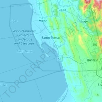
Name: Santo Tomas topographic map, elevation, terrain.
Location: Santo Tomas, La Union, Ilocos Region, Philippines (16.19263 120.20158 16.30898 120.44816)
Average elevation: 194 ft
Minimum elevation: -3 ft
Maximum elevation: 2,841 ft
Other topographic maps
Click on a map to view its topography, its elevation and its terrain.
San Fernando
Philippines > La Union > San Fernando
San Fernando, La Union, Ilocos, 2500, Philippines
Average elevation: 266 ft