
Make a donation
Gear up for your next adventure:
As an Amazon Associate, this site earns from qualifying purchases at no extra cost to you.
Hiwassee topographic map
Click on the map to display elevation.
Make a donation
Gear up for your next adventure:
As an Amazon Associate, this site earns from qualifying purchases at no extra cost to you.
About this map
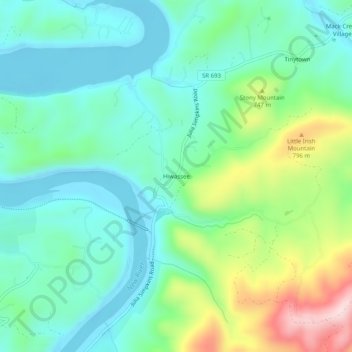
Name: Hiwassee topographic map, elevation, terrain.
Location: Hiwassee, Pulaski County, Virginia, 24347, United States (36.94873 -80.73368 36.98873 -80.69368)
Average elevation: 2,146 ft
Minimum elevation: 1,844 ft
Maximum elevation: 2,959 ft
Pulaski County trails, hiking, mountain biking, running and outdoor activities
Make a donation
Gear up for your next adventure:
As an Amazon Associate, this site earns from qualifying purchases at no extra cost to you.
Other topographic maps
Click on a map to view its topography, its elevation and its terrain.
Claytor Lake State Park
United States > Virginia > Pulaski County > Dublin
Average elevation: 1,893 ft
Make a donation
Gear up for your next adventure:
As an Amazon Associate, this site earns from qualifying purchases at no extra cost to you.