
Damm topographic map
Interactive map
Click on the map to display elevation.
About this map
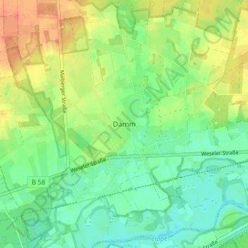
Name: Damm topographic map, elevation, terrain.
Location: Damm, Schermbeck, Kreis Wesel, North Rhine-Westphalia, Germany (51.66540 6.78080 51.70540 6.82080)
Average elevation: 128 ft
Minimum elevation: 72 ft
Maximum elevation: 203 ft
Other topographic maps
Click on a map to view its topography, its elevation and its terrain.
Brünen
Germany > North Rhine-Westphalia > Kreis Wesel > Hamminkeln
Brünen, Hamminkeln, Kreis Wesel, North Rhine-Westphalia, Germany
Average elevation: 128 ft