
Dibba Al Fujairah topographic map
Interactive map
Click on the map to display elevation.
About this map
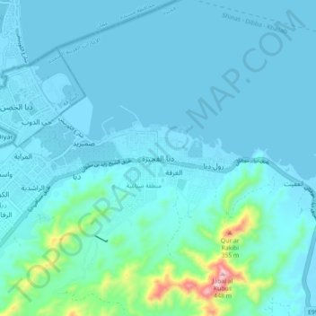
Name: Dibba Al Fujairah topographic map, elevation, terrain.
Location: Dibba Al Fujairah, Fujairah Emirate, United Arab Emirates (25.56226 56.26707 25.64226 56.34707)
Average elevation: 154 ft
Minimum elevation: -7 ft
Maximum elevation: 1,539 ft
Other topographic maps
Click on a map to view its topography, its elevation and its terrain.
Wam
United Arab Emirates > Fujairah Emirate
Wam, Fujairah Emirate, United Arab Emirates
Average elevation: 1,112 ft
Sharm
United Arab Emirates > Fujairah Emirate
Sharm, Fujairah Emirate, United Arab Emirates
Average elevation: 449 ft
Tawian Dam
United Arab Emirates > Fujairah Emirate
Tawian Dam, Fujairah Emirate, United Arab Emirates
Average elevation: 653 ft
Dibba
United Arab Emirates > Fujairah Emirate > Dibba
Dibba, Fujairah Emirate, United Arab Emirates
Average elevation: 174 ft
Fujairah
United Arab Emirates > Fujairah Emirate
Fujairah, Fujairah Emirate, United Arab Emirates
Average elevation: 236 ft