
Daun topographic map
Interactive map
Click on the map to display elevation.
About this map
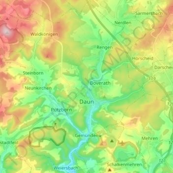
Name: Daun topographic map, elevation, terrain.
Average elevation: 1,591 ft
Minimum elevation: 1,155 ft
Maximum elevation: 2,283 ft
Other topographic maps
Click on a map to view its topography, its elevation and its terrain.
Stadtkyll
Allemagne > Rhénanie-Palatinat > Landkreis Vulkaneifel
Stadtkyll, Gerolstein, Landkreis Vulkaneifel, Rhénanie-Palatinat, 54589, Allemagne
Average elevation: 1,775 ft
Kerpen (Eifel)
Allemagne > Rhénanie-Palatinat > Landkreis Vulkaneifel > Kerpen (Eifel)
Kerpen (Eifel), Gerolstein, Landkreis Vulkaneifel, Rhénanie-Palatinat, Allemagne
Average elevation: 1,578 ft