
Onkerzele topographic map
Interactive map
Click on the map to display elevation.
About this map
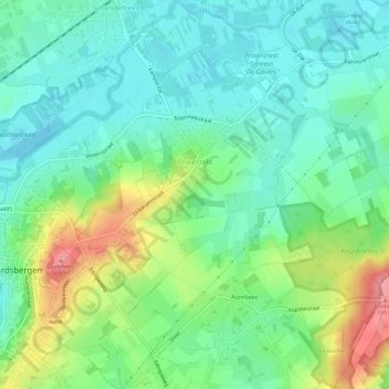
Name: Onkerzele topographic map, elevation, terrain.
Location: Onkerzele, Grammont, Alost, Flandre orientale, Flandre, Belgique (50.76006 3.87995 50.79753 3.93155)
Average elevation: 125 ft
Minimum elevation: 20 ft
Maximum elevation: 354 ft
Le village est situé le long de la Dendre. L'altitude varie de 15 à 95 mètres.
Other topographic maps
Click on a map to view its topography, its elevation and its terrain.
Schendelbeke
Belgique > Flandre orientale > Alost > Grammont
Schendelbeke, Grammont, Alost, Flandre orientale, Flandre, 9506, Belgique
Average elevation: 79 ft