
Vlotho topographic map
Interactive map
Click on the map to display elevation.
About this map
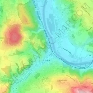
Name: Vlotho topographic map, elevation, terrain.
Location: Vlotho, Kreis Herford, Noordrijn-Westfalen, 32602, Duitsland (52.15440 8.83857 52.18889 8.89170)
Average elevation: 390 ft
Minimum elevation: 138 ft
Maximum elevation: 879 ft
Other topographic maps
Click on a map to view its topography, its elevation and its terrain.
Bonneberg
Duitsland > Noordrijn-Westfalen > Kreis Herford > Vlotho > Bonneberg
Bonneberg, Vlotho, Kreis Herford, Noordrijn-Westfalen, 32602, Duitsland
Average elevation: 492 ft