
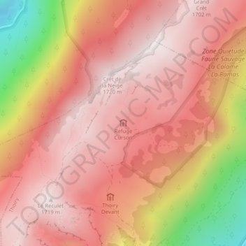
Refuge Curson topographic map
Interactive map
Click on the map to display elevation.
About this map
Name: Refuge Curson topographic map, elevation, terrain.
Average elevation: 4,721 ft
Minimum elevation: 2,710 ft
Maximum elevation: 5,610 ft
Other topographic maps
Click on a map to view its topography, its elevation and its terrain.
Allemogne
France > Auvergne-Rhône-Alpes > Ain > Thoiry
Allemogne, Thoiry, Gex, Ain, Auvergne-Rhône-Alpes, France métropolitaine, 01710, France
Average elevation: 1,896 ft
Baizenas
France > Auvergne-Rhône-Alpes > Ain > Thoiry
Baizenas, Thoiry, Gex, Ain, Auvergne-Rhône-Alpes, France métropolitaine, 01710, France
Average elevation: 1,903 ft
Le Tiocan
France > Auvergne-Rhône-Alpes > Ain > Thoiry
Le Tiocan, Place du Belvédère, Thoiry, Gex, Ain, Auvergne-Rhône-Alpes, France métropolitaine, 01710, France
Average elevation: 2,963 ft
Le Reculet
France > Auvergne-Rhône-Alpes > Ain > Thoiry
Le Reculet, Thoiry, Gex, Ain, Auvergne-Rhône-Alpes, France métropolitaine, 01710, France
Average elevation: 4,616 ft
Tiocan
France > Auvergne-Rhône-Alpes > Ain > Thoiry
Tiocan, Place du Belvédère, Thoiry, Gex, Ain, Auvergne-Rhône-Alpes, France métropolitaine, 01710, France
Average elevation: 2,923 ft