
Dehesa de Campoamor topographic map
Interactive map
Click on the map to display elevation.
About this map
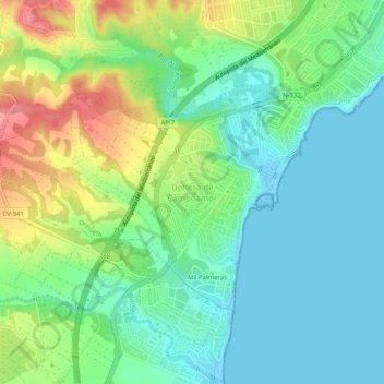
Name: Dehesa de Campoamor topographic map, elevation, terrain.
Average elevation: 92 ft
Minimum elevation: -23 ft
Maximum elevation: 276 ft
Other topographic maps
Click on a map to view its topography, its elevation and its terrain.
Cabo Roig
Espagne > Communauté Valencienne > el Baix Segura / La Vega Baja del Segura > Orihuela
Cabo Roig, Orihuela, el Baix Segura / La Vega Baja del Segura, Alicante, Communauté Valencienne, 03189, Espagne
Average elevation: 30 ft