
Palos Caídos topographic map
Interactive map
Click on the map to display elevation.
About this map
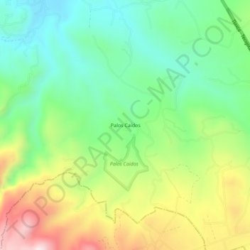
Name: Palos Caídos topographic map, elevation, terrain.
Location: Palos Caídos, Zacatlán, Puebla, México (19.95833 -98.13444 19.99833 -98.09444)
Average elevation: 8,068 ft
Minimum elevation: 7,395 ft
Maximum elevation: 9,199 ft
Other topographic maps
Click on a map to view its topography, its elevation and its terrain.
Atzingo (La Cumbre)
Atzingo (La Cumbre), Zacatlán, Puebla, 73313, México
Average elevation: 6,982 ft
San Miguel Tenango
San Miguel Tenango, Zacatlán, Puebla, 73310, México
Average elevation: 6,375 ft
Poxcuatzingo
México > Puebla > Zacatlán > Jicolapa
Poxcuatzingo, Jicolapa, Zacatlán, Puebla, 73313, México
Average elevation: 7,218 ft