Geolocate

Quitman topographic map

Click on the map to display elevation.

About this map

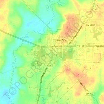
Name: Quitman topographic map, elevation, terrain.

Location: Quitman, Wood County, Texas, 75783, United States (32.77681 -95.46187 32.81066 -95.42037)

Average elevation: 394 ft

Minimum elevation: 318 ft

Maximum elevation: 456 ft

Wood County trails, hiking, mountain biking, running and outdoor activities

Other topographic maps

Click on a map to view its topography, its elevation and its terrain.

Concord

United States > Texas > Wood County

Average elevation: 420 ft

Holly Lake Ranch

United States > Texas > Wood County

Average elevation: 400 ft

Angler

United States > Texas > Wood County

Average elevation: 331 ft

Calvary

United States > Texas > Wood County

Average elevation: 433 ft

Gear up for your next adventure:

🔭Compact Binoculars - HD vision for scouting terrain and identifying distant landmarks
🚗GPS Dash Cams - Record your scenic drives through mountain passes and canyons
🪵Folding Camp Saw - Compact saw for wood and campsite work
🥾Men's Hiking Boots - Durable, waterproof footwear for rugged terrain and steep inclines
🏫Relief Map Kits - Hands-on tools for teaching landforms and elevation

As an Amazon Associate, this site earns from qualifying purchases at no extra cost to you.