
Colebrook topographic map
Click on the map to display elevation.
About this map
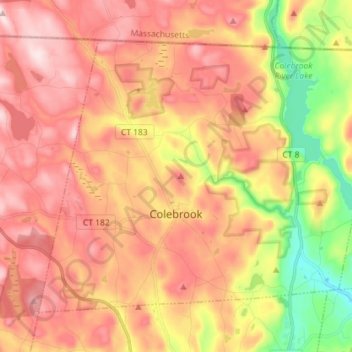
Name: Colebrook topographic map, elevation, terrain.
Average elevation: 1,184 ft
Minimum elevation: 512 ft
Maximum elevation: 1,673 ft
Northwest Hills Planning Region trails, hiking, mountain biking, running and outdoor activities
Other topographic maps
Click on a map to view its topography, its elevation and its terrain.
Yellow Mountain
United States > Northwest Hills Planning Region > New Hartford
Average elevation: 732 ft
Town of Barkhamsted property
United States > Northwest Hills Planning Region > Barkhamsted
Average elevation: 1,033 ft
East Litchfield
United States > Northwest Hills Planning Region > Litchfield
Average elevation: 784 ft