
Huyện Kbang topographic map
Interactive map
Click on the map to display elevation.
About this map
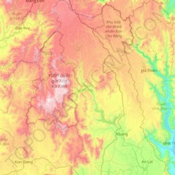
Name: Huyện Kbang topographic map, elevation, terrain.
Location: Huyện Kbang, Province de Gia Lai, 62600, Viêt Nam (13.99965 108.29151 14.60316 108.68695)
Average elevation: 2,667 ft
Minimum elevation: 131 ft
Maximum elevation: 5,712 ft
Other topographic maps
Click on a map to view its topography, its elevation and its terrain.
Pleiku
Viêt Nam > Province de Gia Lai
Pleiku, Province de Gia Lai, Viêt Nam
Average elevation: 2,375 ft
Kông Chro
Viêt Nam > Province de Gia Lai
Kông Chro, Province de Gia Lai, Viêt Nam
Average elevation: 1,562 ft