
Make a donation
Gear up for your next adventure:
As an Amazon Associate, this site earns from qualifying purchases at no extra cost to you.
Tequila topographic map
Click on the map to display elevation.
Make a donation
Gear up for your next adventure:
As an Amazon Associate, this site earns from qualifying purchases at no extra cost to you.
Tequila
Tequila is one of the 124 municipalities of Jalisco, located just west of the center of the state. Its territory extends for 1689.11km2, with elevations that vary between 700 and 2,900 meters above sea level. The municipality borders with the main metropolitan region of Guadalajara to the east (Zapopan), and the State of Zacatecas to the north. All of the neighboring municipalities surrounding Mount Tequila conform the greater region of 'Tequila'. These include the adjacent municipalities of Amatitlán, Magdalena, San Juanito de Escobedo, San Martín de Bolaños, San Cristóbal de la Barranca, Hostotipaquillo and, south of Tequila Volcano: Teuchtilán and Ahualulco de Mercado. The original land-subdivision of the region was delineated by the Agave-growing haciendas that are found throughout.
Make a donation
Gear up for your next adventure:
As an Amazon Associate, this site earns from qualifying purchases at no extra cost to you.
About this map
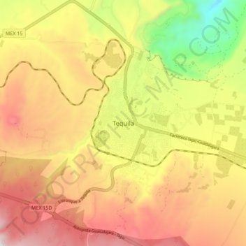
Name: Tequila topographic map, elevation, terrain.
Location: Tequila, Región Valles, Jalisco, Mexico (20.84212 -103.87709 20.92212 -103.79709)
Average elevation: 4,157 ft
Minimum elevation: 2,264 ft
Maximum elevation: 5,738 ft
Make a donation
Gear up for your next adventure:
As an Amazon Associate, this site earns from qualifying purchases at no extra cost to you.
Other topographic maps
Click on a map to view its topography, its elevation and its terrain.