
Mont Bisanne topographic map
Interactive map
Click on the map to display elevation.
About this map
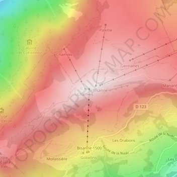
Name: Mont Bisanne topographic map, elevation, terrain.
Average elevation: 5,292 ft
Minimum elevation: 3,110 ft
Maximum elevation: 6,365 ft
Other topographic maps
Click on a map to view its topography, its elevation and its terrain.
Bisanne 1500
France > Auvergne-Rhône-Alpes > Savoie > Villard-sur-Doron
Bisanne 1500, Villard-sur-Doron, Albertville, Savoie, Auvergne-Rhône-Alpes, France métropolitaine, 73270, France
Average elevation: 4,370 ft
Le Doron
France > Auvergne-Rhône-Alpes > Savoie > Villard-sur-Doron
Le Doron, Villard-sur-Doron, Albertville, Savoie, Auvergne-Rhône-Alpes, France métropolitaine, 73270, France
Average elevation: 4,406 ft