
Thank you for supporting this site ❤️
Make a donation
Make a donation
Gear up for your next adventure:
As an Amazon Associate, this site earns from qualifying purchases at no extra cost to you.
Grez-Doiceau topographic map
Click on the map to display elevation.
Thank you for supporting this site ❤️
Make a donation
Make a donation
Gear up for your next adventure:
As an Amazon Associate, this site earns from qualifying purchases at no extra cost to you.
About this map
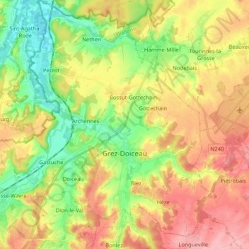
Name: Grez-Doiceau topographic map, elevation, terrain.
Location: Grez-Doiceau, Nivelles, Walloon Brabant, Wallonia, 1390, Belgium (50.70057 4.62028 50.79936 4.75032)
Average elevation: 266 ft
Minimum elevation: 75 ft
Maximum elevation: 476 ft
Thank you for supporting this site ❤️
Make a donation
Make a donation
Gear up for your next adventure:
As an Amazon Associate, this site earns from qualifying purchases at no extra cost to you.