
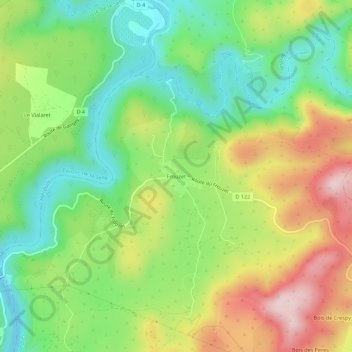
Frouzet topographic map
Interactive map
Click on the map to display elevation.
About this map
Name: Frouzet topographic map, elevation, terrain.
Average elevation: 732 ft
Minimum elevation: 299 ft
Maximum elevation: 1,345 ft
Other topographic maps
Click on a map to view its topography, its elevation and its terrain.
Les Parras
France > Occitanie > Hérault > Saint-Martin-de-Londres
Les Parras, Saint-Martin-de-Londres, Lodève, Hérault, Occitanie, France métropolitaine, 34380, France
Average elevation: 840 ft
Combe Garone
France > Occitanie > Hérault > Saint-Martin-de-Londres
Combe Garone, Saint-Martin-de-Londres, Lodève, Hérault, Occitanie, France métropolitaine, 34380, France
Average elevation: 984 ft
Croix de Lauret
France > Occitanie > Hérault > Saint-Martin-de-Londres
Croix de Lauret, Saint-Martin-de-Londres, Lodève, Hérault, Occitanie, France métropolitaine, 34380, France
Average elevation: 863 ft