
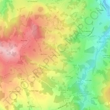
La Petite Faye topographic map
Interactive map
Click on the map to display elevation.
About this map
Name: La Petite Faye topographic map, elevation, terrain.
Average elevation: 1,388 ft
Minimum elevation: 1,017 ft
Maximum elevation: 1,739 ft
Other topographic maps
Click on a map to view its topography, its elevation and its terrain.
La Barre
France > Nouvelle-Aquitaine > Creuse > Clugnat
La Barre, Clugnat, Aubusson, Creuse, Nouvelle-Aquitaine, France métropolitaine, 23270, France
Average elevation: 1,102 ft
Doulon
France > Nouvelle-Aquitaine > Creuse > Clugnat
Doulon, Clugnat, Aubusson, Creuse, Nouvelle-Aquitaine, France métropolitaine, 23270, France
Average elevation: 1,352 ft
Le Courtioux
France > Nouvelle-Aquitaine > Creuse > Clugnat > Le Courtioux
Le Courtioux, Clugnat, Aubusson, Creuse, Nouvelle-Aquitaine, France métropolitaine, 23270, France
Average elevation: 1,434 ft