
La Gran Sabana topographic map
Interactive map
Click on the map to display elevation.
About this map
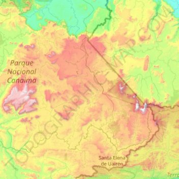
Name: La Gran Sabana topographic map, elevation, terrain.
Average elevation: 2,828 ft
Minimum elevation: 259 ft
Maximum elevation: 9,173 ft
Other topographic maps
Click on a map to view its topography, its elevation and its terrain.
Canaima
Venezuela > Bolivar State > Municipio Gran Sabana
Canaima, Parroquia Gran Sabana, Municipio Gran Sabana, Bolivar State, Venezuela
Average elevation: 1,476 ft
Auyán Tepuy
Venezuela > Bolivar State > Municipio Gran Sabana
Auyán Tepuy, Parroquia Gran Sabana, Municipio Gran Sabana, Bolivar State, Venezuela
Average elevation: 5,528 ft
Parroquia Gran Sabana
Venezuela > Bolivar State > Municipio Gran Sabana
Parroquia Gran Sabana, Municipio Gran Sabana, Bolivar State, 8011, Venezuela
Average elevation: 2,480 ft