
Make a donation
Gear up for your next adventure:
As an Amazon Associate, this site earns from qualifying purchases at no extra cost to you.
Khorramabad topographic map
Click on the map to display elevation.
Make a donation
Gear up for your next adventure:
As an Amazon Associate, this site earns from qualifying purchases at no extra cost to you.
Khorramabad
Khorramabad has mild and semi-humid Mediterranean climate with high amount of rainfall during spring and winter. It is the sixth cities in Iran having high level of annual rainfall. Khorramabad has what is classed under the Köppen climate classification as a Hot-summer Mediterranean climate (Csa) climate. Its elevation is 1147.8 above sea level. Average annual precipitation is 511.06 and its average annual temperature is 17.21 Celsius.
Make a donation
Gear up for your next adventure:
As an Amazon Associate, this site earns from qualifying purchases at no extra cost to you.
About this map
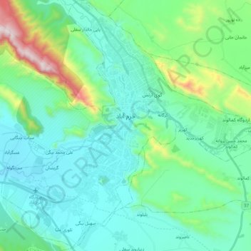
Name: Khorramabad topographic map, elevation, terrain.
Average elevation: 4,488 ft
Minimum elevation: 3,694 ft
Maximum elevation: 7,844 ft
Make a donation
Gear up for your next adventure:
As an Amazon Associate, this site earns from qualifying purchases at no extra cost to you.
Other topographic maps
Click on a map to view its topography, its elevation and its terrain.
Nasirabad
Iran > Lorestan Province > Khorramabad County > دهستان کاکاشرف > Cham Bagh
Average elevation: 5,013 ft