Geolocate

Fustat topographic map

Click on the map to display elevation.

About this map

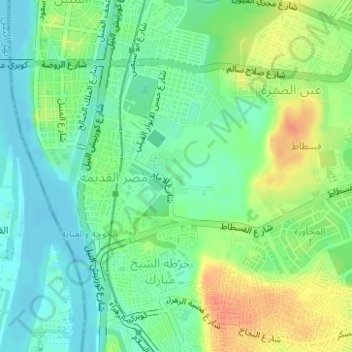
Name: Fustat topographic map, elevation, terrain.

Location: Fustat, Masr Al-Qadima, EL Sheikh Mubarak, Cairo, Egypt (30.00367 31.22957 30.01080 31.24035)

Average elevation: 95 ft

Minimum elevation: 39 ft

Maximum elevation: 184 ft

Gear up for your next adventure:

Solar GPS Watches - Advanced multisport watches with built-in topographic maps
🎒Day Hiking Backpack - Lightweight backpack perfect for day trips and outdoor adventures
🛰️Satellite Messengers - Emergency SOS and two-way messaging for off-grid adventures
👟Trail Running Shoes - Lightweight shoes for trail runners
📚USA Hiking Guide Books - Top trail guides and map books

As an Amazon Associate, this site earns from qualifying purchases at no extra cost to you.