
Make a donation
Gear up for your next adventure:
As an Amazon Associate, this site earns from qualifying purchases at no extra cost to you.
Aktobe topographic map
Click on the map to display elevation.
Make a donation
Gear up for your next adventure:
As an Amazon Associate, this site earns from qualifying purchases at no extra cost to you.
Aktobe
After the territories of modern Kazakhstan were annexed to the Russian Empire, due to the need for strong points and retail outlets, many cities appeared, one of which was Aktobe. In the architecture of the cities of Southern Kazakhstan, the influence of the Central Asian khanates is traced, and the settlements in the west and north-west were typically Russian provincial cities. These cities were built on the basis of master plans drawn up by Russian topographers. The first master plan of Aktobe was developed in 1874. Eclecticism is inherent in Aktobe architecture - new buildings are adjacent to houses built in the Soviet period, occasionally there are buildings that have survived from pre-revolutionary times. One of the oldest buildings in the city - the Russian-Kyrgyz women's school, built in 1894, is located on Aiteke bi. Today this building is occupied by the" Shahrizad "restaurant. The building of the former House of Culture of Railway Workers (now the Lokomotiv Cinema), built in 1928 in the constructivist style, is included in the list of historical and cultural monuments of Kazakhstan of republican significance.
Make a donation
Gear up for your next adventure:
As an Amazon Associate, this site earns from qualifying purchases at no extra cost to you.
About this map
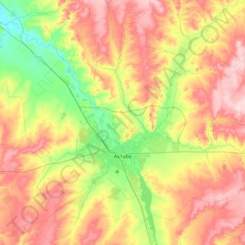
Name: Aktobe topographic map, elevation, terrain.
Location: Aktobe, Astana District, Aqtöbe Region, Kazakhstan (50.12348 56.85913 50.60327 57.77285)
Average elevation: 928 ft
Minimum elevation: 584 ft
Maximum elevation: 1,362 ft
Make a donation
Gear up for your next adventure:
As an Amazon Associate, this site earns from qualifying purchases at no extra cost to you.