Geolocate

Inzell topographic map

Click on the map to display elevation.

About this map

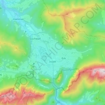
Name: Inzell topographic map, elevation, terrain.

Location: Inzell, Landkreis Traunstein, Bavaria, 83334, Germany (47.73287 12.71059 47.81037 12.84862)

Average elevation: 3,048 ft

Minimum elevation: 2,031 ft

Maximum elevation: 5,758 ft

Gear up for your next adventure:

🧭Map Reading Tools - Tools and kits for map navigation
🪶LED Camping Lantern - Bright lantern for camp lighting
🕶️GPS Smartphone Mount - Secure mount for phone navigation
🛠️Backpacking Tool Kit - Essential toolkit for outdoor repairs
📌Outdoor GPS Map App - Apps and devices for digital topographic navigation

As an Amazon Associate, this site earns from qualifying purchases at no extra cost to you.