
Parroquia Mene Mauroa topographic map
Interactive map
Click on the map to display elevation.
About this map
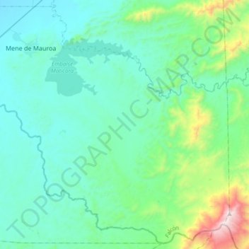
Name: Parroquia Mene Mauroa topographic map, elevation, terrain.
Average elevation: 928 ft
Minimum elevation: 144 ft
Maximum elevation: 5,167 ft
Other topographic maps
Click on a map to view its topography, its elevation and its terrain.
Las Piedras
Venezuela > Falcón > Las Piedras
Las Piedras, Municipio Carirubana, Falcón, 4102, Venezuela
Average elevation: 39 ft
Distrito Carirubana
Distrito Carirubana, Falcón, Región Centroccidental, Venezuela
Average elevation: 207 ft