
Make a donation
Gear up for your next adventure:
As an Amazon Associate, this site earns from qualifying purchases at no extra cost to you.
Nußdorf am Inn topographic map
Click on the map to display elevation.
Make a donation
Gear up for your next adventure:
As an Amazon Associate, this site earns from qualifying purchases at no extra cost to you.
About this map
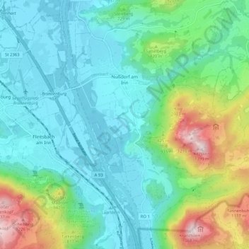
Name: Nußdorf am Inn topographic map, elevation, terrain.
Location: Nußdorf am Inn, Landkreis Rosenheim, Bavaria, 83131, Germany (47.70050 12.12924 47.75904 12.23110)
Average elevation: 2,162 ft
Minimum elevation: 1,467 ft
Maximum elevation: 4,426 ft
Make a donation
Gear up for your next adventure:
As an Amazon Associate, this site earns from qualifying purchases at no extra cost to you.
Other topographic maps
Click on a map to view its topography, its elevation and its terrain.
Kampenwand-Hauptgipfel
Germany > Bavaria > Landkreis Rosenheim > Aschau im Chiemgau
Average elevation: 4,173 ft
Make a donation
Gear up for your next adventure:
As an Amazon Associate, this site earns from qualifying purchases at no extra cost to you.
Make a donation
Gear up for your next adventure:
As an Amazon Associate, this site earns from qualifying purchases at no extra cost to you.
Wasserburg am Inn
Germany > Bavaria > Landkreis Rosenheim > Wasserburg am Inn > Wasserburg am Inn
Average elevation: 1,565 ft
Geigelstein
Germany > Bavaria > Landkreis Rosenheim > Aschau im Chiemgau
Geigelstein is a mountain in Bavaria, Germanywith an elevation of 1,808 meters. It is a mountain within the Chiemgau Alps.
Average elevation: 4,734 ft