
Make a donation
Gear up for your next adventure:
As an Amazon Associate, this site earns from qualifying purchases at no extra cost to you.
Gütersloh topographic map
Click on the map to display elevation.
Make a donation
Gear up for your next adventure:
As an Amazon Associate, this site earns from qualifying purchases at no extra cost to you.
Gütersloh
Gütersloh lies in the Emssandebene, south-west of the Teutoburg Forest and on the north-eastern edge of the Westphalian Basin and has no significant points of elevation. The city's lowest point is 64 metres (210 ft) above sea level on the river Ems near the Princess Royal Barracks and the highest point is 105 metres (344 ft) above sea level in the eastern township of Friedrichsdorf.
Make a donation
Gear up for your next adventure:
As an Amazon Associate, this site earns from qualifying purchases at no extra cost to you.
About this map
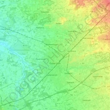
Name: Gütersloh topographic map, elevation, terrain.
Location: Gütersloh, Kreis Gütersloh, North Rhine-Westphalia, Germany (51.85597 8.28400 51.97709 8.50599)
Average elevation: 262 ft
Minimum elevation: 200 ft
Maximum elevation: 390 ft
Make a donation
Gear up for your next adventure:
As an Amazon Associate, this site earns from qualifying purchases at no extra cost to you.
Other topographic maps
Click on a map to view its topography, its elevation and its terrain.
Emsquelle
Germany > North Rhine-Westphalia > Kreis Gütersloh > Schloß Holte-Stukenbrock
Average elevation: 443 ft