
Poreta topographic map
Interactive map
Click on the map to display elevation.
About this map
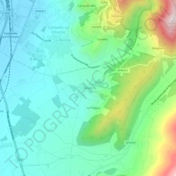
Name: Poreta topographic map, elevation, terrain.
Location: Poreta, Spolète, Perugia, Ombrie, 06049, Italie (42.78957 12.76540 42.82957 12.80540)
Average elevation: 1,339 ft
Minimum elevation: 722 ft
Maximum elevation: 3,136 ft
Other topographic maps
Click on a map to view its topography, its elevation and its terrain.