Geolocate

Cedar Keys topographic map

Click on the map to display elevation.

About this map

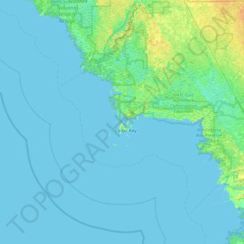
Name: Cedar Keys topographic map, elevation, terrain.

Location: Cedar Keys, Levy County, Florida, 32625, USA (28.83802 -83.36651 29.47802 -82.72651)

Average elevation: 10 ft

Minimum elevation: -3 ft

Maximum elevation: 66 ft

Other topographic maps

Click on a map to view its topography, its elevation and its terrain.

Lake Tarpon

USA > Florida > Lake Shore Estates

Average elevation: 26 ft

Lake Kissimmee

USA > Florida

Average elevation: 56 ft

Julington Creek

USA > Florida > Jacksonville

Average elevation: 20 ft

Gear up for your next adventure:

🌡️Handheld Weather Meters - Measure wind, temp, and pressure for safe mountain travel
🎁Geography Themed Gifts - Unique gift ideas for map lovers and geography enthusiasts
🥾Hiking Shoes - Durable and comfortable shoes for trail hiking
☀️Outdoor Sunscreen - High protection sunscreen for outdoor activities
🧯Emergency Survival Kit - All‑in‑one survival essentials for the backcountry

As an Amazon Associate, this site earns from qualifying purchases at no extra cost to you.