
Emmerich on the Rhine topographic map
Interactive map
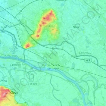
Click on the map to display elevation.
About this map
Name: Emmerich on the Rhine topographic map, elevation, terrain.
Average elevation: 59 ft
Minimum elevation: 23 ft
Maximum elevation: 328 ft
Other topographic maps
Click on a map to view its topography, its elevation and its terrain.
In der Lecht
Germany > North Rhine-Westphalia > Kreis Kleve > Kalkar
In der Lecht, Kalkar, Bedburg-Hau, Kreis Kleve, North Rhine-Westphalia, 47546, Germany
Average elevation: 112 ft
Bennenbroek
Germany > North Rhine-Westphalia > Kreis Kleve > Straelen
Bennenbroek, Straelen, Kreis Kleve, North Rhine-Westphalia, 47638, Germany
Average elevation: 79 ft
Goch
Germany > North Rhine-Westphalia > Kreis Kleve
Goch, Kreis Kleve, North Rhine-Westphalia, 47574, Germany
Average elevation: 79 ft
Geldern
Germany > North Rhine-Westphalia > Kreis Kleve
Geldern, Kreis Kleve, North Rhine-Westphalia, 47608, Germany
Average elevation: 92 ft
Uedem
Germany > North Rhine-Westphalia > Kreis Kleve > Uedem
Uedem, Kreis Kleve, North Rhine-Westphalia, 47589, Germany
Average elevation: 102 ft
Kalkar
Germany > North Rhine-Westphalia > Kreis Kleve > Kalkar
Kalkar, Kreis Kleve, North Rhine-Westphalia, 47546, Germany
Average elevation: 72 ft
Wachtendonk
Germany > North Rhine-Westphalia > Kreis Kleve > Wachtendonk
Wachtendonk, Kreis Kleve, North Rhine-Westphalia, 47669, Germany
Average elevation: 115 ft
Jan
Germany > North Rhine-Westphalia > Kreis Kleve > Kranenburg
Jan, Kranenburg, Kreis Kleve, North Rhine-Westphalia, Germany
Average elevation: 89 ft
Issum
Germany > North Rhine-Westphalia > Kreis Kleve
Issum, Kreis Kleve, North Rhine-Westphalia, 47661, Germany
Average elevation: 102 ft