
Gelselaar topographic map
Interactive map
Click on the map to display elevation.
About this map
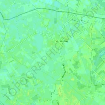
Name: Gelselaar topographic map, elevation, terrain.
Location: Gelselaar, Berkelland, Gelderland, Nederland (52.14851 6.49218 52.18131 6.55535)
Average elevation: 49 ft
Minimum elevation: 33 ft
Maximum elevation: 59 ft
Other topographic maps
Click on a map to view its topography, its elevation and its terrain.
Rietmolen
Nederland > Gelderland > Berkelland
Rietmolen, Berkelland, Gelderland, Nederland
Average elevation: 66 ft
Kasteel Huize Ruurlo
Nederland > Gelderland > Berkelland
Kasteel Huize Ruurlo, Vordenseweg, Ruurlo, Berkelland, Gelderland, Nederland, 7261LM, Nederland
Average elevation: 59 ft