
Make a donation
Gear up for your next adventure:
As an Amazon Associate, this site earns from qualifying purchases at no extra cost to you.
Lewis Mountain topographic map
Click on the map to display elevation.
Make a donation
Gear up for your next adventure:
As an Amazon Associate, this site earns from qualifying purchases at no extra cost to you.
About this map
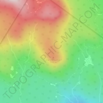
Name: Lewis Mountain topographic map, elevation, terrain.
Location: Lewis Mountain, Lewis, Essex County, Vermont, United States (44.89989 -71.77089 44.89999 -71.77079)
Average elevation: 2,126 ft
Minimum elevation: 1,512 ft
Maximum elevation: 2,831 ft
Essex County trails, hiking, mountain biking, running and outdoor activities
Make a donation
Gear up for your next adventure:
As an Amazon Associate, this site earns from qualifying purchases at no extra cost to you.
Other topographic maps
Click on a map to view its topography, its elevation and its terrain.
Silvio O. Conte National Fish And Wildlife Refuge
United States > Vermont > Essex County > Lewis
Average elevation: 699 ft