
Make a donation
Gear up for your next adventure:
As an Amazon Associate, this site earns from qualifying purchases at no extra cost to you.
Hillcrest topographic map
Click on the map to display elevation.
Make a donation
Gear up for your next adventure:
As an Amazon Associate, this site earns from qualifying purchases at no extra cost to you.
Hillcrest
Hillcrest is situated in the Upper Highway Area of Durban, approximately 32 kilometres (20 mi) north-west of the city and is bordered by Gillitts and Everton to the east, Waterfall to the north-east and Botha's Hill and Assagay to the north-west. It lies at an altitude of approximately 680 m (2231 ft) above sea level in the Valley of a Thousand Hills, just above Durban.
Make a donation
Gear up for your next adventure:
As an Amazon Associate, this site earns from qualifying purchases at no extra cost to you.
About this map
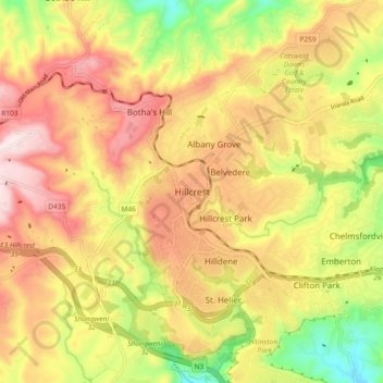
Name: Hillcrest topographic map, elevation, terrain.
Average elevation: 2,051 ft
Minimum elevation: 1,234 ft
Maximum elevation: 2,743 ft
Make a donation
Gear up for your next adventure:
As an Amazon Associate, this site earns from qualifying purchases at no extra cost to you.
Other topographic maps
Click on a map to view its topography, its elevation and its terrain.
Inanda Dam
South Africa > KwaZulu-Natal > eThekwini Metropolitan Municipality
Average elevation: 728 ft
Umgeni River
South Africa > KwaZulu-Natal > eThekwini Metropolitan Municipality > Queensburgh
Average elevation: 430 ft
uMngeni River
South Africa > KwaZulu-Natal > eThekwini Metropolitan Municipality
Average elevation: 1,962 ft
Umhlanga River
South Africa > KwaZulu-Natal > eThekwini Metropolitan Municipality > Phoenix
Average elevation: 427 ft
Make a donation
Gear up for your next adventure:
As an Amazon Associate, this site earns from qualifying purchases at no extra cost to you.
Pigeon Valley
South Africa > KwaZulu-Natal > eThekwini Metropolitan Municipality > Durban
Average elevation: 226 ft
Umbilo River
South Africa > KwaZulu-Natal > eThekwini Metropolitan Municipality > Durban
Average elevation: 184 ft
Bluff Nature Reserve
South Africa > KwaZulu-Natal > eThekwini Metropolitan Municipality > Durban
Average elevation: 125 ft
Make a donation
Gear up for your next adventure:
As an Amazon Associate, this site earns from qualifying purchases at no extra cost to you.
uMngeni River
South Africa > KwaZulu-Natal > eThekwini Metropolitan Municipality
Average elevation: 1,962 ft
eThekwini Ward 32
South Africa > KwaZulu-Natal > eThekwini Metropolitan Municipality
Average elevation: 82 ft
Make a donation
Gear up for your next adventure:
As an Amazon Associate, this site earns from qualifying purchases at no extra cost to you.
Umgeni River
South Africa > KwaZulu-Natal > eThekwini Metropolitan Municipality > Queensburgh
Average elevation: 430 ft
Umbilo River
South Africa > KwaZulu-Natal > eThekwini Metropolitan Municipality > Durban
Average elevation: 184 ft
Plantations
South Africa > KwaZulu-Natal > eThekwini Metropolitan Municipality > Hillcrest
Average elevation: 2,070 ft