
Trussville topographic map
Interactive map
Click on the map to display elevation.
About this map
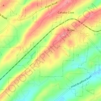
Name: Trussville topographic map, elevation, terrain.
Location: Trussville, Jefferson County, Alabama, United States (33.60001 -86.58747 33.60203 -86.58664)
Average elevation: 794 ft
Minimum elevation: 633 ft
Maximum elevation: 938 ft
Other topographic maps
Click on a map to view its topography, its elevation and its terrain.
Trussville Manor
United States > Alabama > Jefferson County > Trussville
Trussville Manor, Trussville, Jefferson County, Alabama, 35173, United States
Average elevation: 778 ft