
Thank you for supporting this site ❤️
Make a donation
Make a donation
Gear up for your next adventure:
As an Amazon Associate, this site earns from qualifying purchases at no extra cost to you.
Maleny topographic map
Click on the map to display elevation.
Thank you for supporting this site ❤️
Make a donation
Make a donation
Gear up for your next adventure:
As an Amazon Associate, this site earns from qualifying purchases at no extra cost to you.
About this map
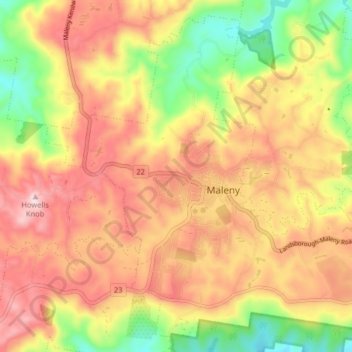
Name: Maleny topographic map, elevation, terrain.
Location: Maleny, Sunshine Coast Regional, Queensland, Australia (-26.78879 152.81233 -26.72281 152.89290)
Average elevation: 1,276 ft
Minimum elevation: 640 ft
Maximum elevation: 1,798 ft
Thank you for supporting this site ❤️
Make a donation
Make a donation
Gear up for your next adventure:
As an Amazon Associate, this site earns from qualifying purchases at no extra cost to you.