
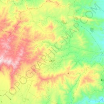
Lubrín topographic map
Interactive map
Click on the map to display elevation.
About this map
Name: Lubrín topographic map, elevation, terrain.
Location: Lubrín, Almería, Andalusië, 04271, Spanje (37.15979 -2.15527 37.29542 -1.98281)
Average elevation: 1,850 ft
Minimum elevation: 623 ft
Maximum elevation: 3,533 ft
Other topographic maps
Click on a map to view its topography, its elevation and its terrain.
La Alameda
Spanje > Andalusië > Lubrín > La Alameda
La Alameda, Lubrín, Almería, Andalusië, 04271, Spanje
Average elevation: 1,575 ft