
Río Sucio topographic map
Interactive map
Click on the map to display elevation.
About this map
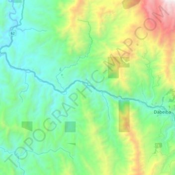
Name: Río Sucio topographic map, elevation, terrain.
Location: Río Sucio, Dabeiba, Occidente, Antioquia, Colombia (6.99152 -76.43143 7.06069 -76.25352)
Average elevation: 2,864 ft
Minimum elevation: 554 ft
Maximum elevation: 9,163 ft
Other topographic maps
Click on a map to view its topography, its elevation and its terrain.
Vda. Llano Grande (ZVTN)
Colombia > Antioquia > Dabeiba
Vda. Llano Grande (ZVTN), Dabeiba, Occidente, Antioquia, RAP del Agua y la Montaña, Colombia
Average elevation: 5,262 ft