
Hüls topographic map
Interactive map
Click on the map to display elevation.
About this map
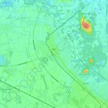
Name: Hüls topographic map, elevation, terrain.
Location: Hüls, Krefeld, Noordrijn-Westfalen, 47839, Duitsland (51.33907 6.47795 51.40199 6.53694)
Average elevation: 121 ft
Minimum elevation: 89 ft
Maximum elevation: 210 ft
Other topographic maps
Click on a map to view its topography, its elevation and its terrain.
Elfrather See
Duitsland > Noordrijn-Westfalen > Krefeld
Elfrather See, Traar, Krefeld, Noordrijn-Westfalen, 47829, Duitsland
Average elevation: 105 ft
Afrika-Savanne
Duitsland > Noordrijn-Westfalen > Krefeld
Afrika-Savanne, Bockum, Krefeld, Noordrijn-Westfalen, 47800, Duitsland
Average elevation: 121 ft