
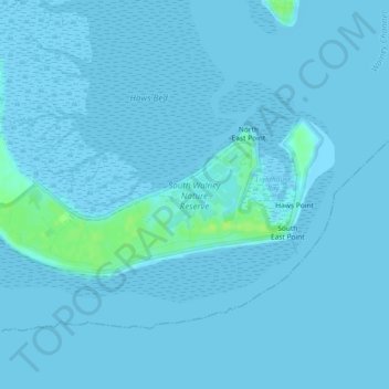
South Walney Nature Reserve topographic map
Interactive map
Click on the map to display elevation.
About this map
Name: South Walney Nature Reserve topographic map, elevation, terrain.
Average elevation: 3 ft
Minimum elevation: 0 ft
Maximum elevation: 36 ft
Other topographic maps
Click on a map to view its topography, its elevation and its terrain.
Dalton Castle
United Kingdom > England > Barrow-in-Furness
Dalton Castle, Market Place, Dalton Town with Newton, Barrow-in-Furness, Cumbria, North West England, England, LA15 8AX, United Kingdom
Average elevation: 200 ft
Lindal and Marton
United Kingdom > England > Barrow-in-Furness
Lindal and Marton, Barrow-in-Furness, Cumbria, North West England, England, United Kingdom
Average elevation: 338 ft