
Sobral topographic map
Interactive map
Click on the map to display elevation.
About this map
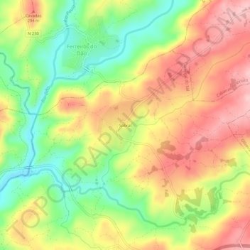
Name: Sobral topographic map, elevation, terrain.
Location: Sobral, Carregal do Sal, Viseu, 3430-056, Portugal (40.43837 -8.04648 40.47837 -8.00648)
Average elevation: 738 ft
Minimum elevation: 417 ft
Maximum elevation: 1,040 ft
Other topographic maps
Click on a map to view its topography, its elevation and its terrain.
Papízios
Portugal > Viseu > Carregal do Sal
Papízios, Carregal do Sal, Viseu, 3430-730, Portugal
Average elevation: 758 ft
Oliveira do Conde
Portugal > Viseu > Carregal do Sal
Oliveira do Conde, Carregal do Sal, Viseu, 3430-420, Portugal
Average elevation: 896 ft