
Mount Weaver topographic map
Interactive map
Click on the map to display elevation.
About this map
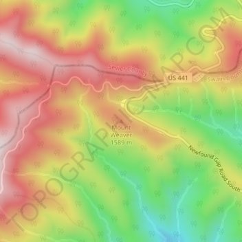
Name: Mount Weaver topographic map, elevation, terrain.
Location: Mount Weaver, Swain County, North Carolina, VS (35.60552 -83.43668 35.60562 -83.43658)
Average elevation: 4,829 ft
Minimum elevation: 3,911 ft
Maximum elevation: 5,633 ft
Other topographic maps
Click on a map to view its topography, its elevation and its terrain.
Margaret
VS > North Carolina > Margaret
Margaret, Franklin County, North Carolina, 27548, VS
Average elevation: 256 ft
Huntersville
VS > North Carolina > Huntersville
Huntersville, Mecklenburg County, North Carolina, 28078, VS
Average elevation: 741 ft
Kaap Hatteras
VS > North Carolina > Buxton
Kaap Hatteras, Ramp 44, Buxton, Dare County, North Carolina, 27952, VS
Average elevation: 3 ft