
Тобольск topographic map
Interactive map
Click on the map to display elevation.
About this map
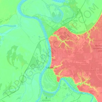
Name: Тобольск topographic map, elevation, terrain.
Average elevation: 190 ft
Minimum elevation: 95 ft
Maximum elevation: 377 ft
Other topographic maps
Click on a map to view its topography, its elevation and its terrain.
Тобольск
Russie > Oblast de Tioumen > городской округ Тобольск > Тобольск
Тобольск, городской округ Тобольск, Oblast de Tioumen, District fédéral de l'Oural, 626152, Russie
Average elevation: 184 ft