
Birtley topographic map
Interactive map
Click on the map to display elevation.
About this map
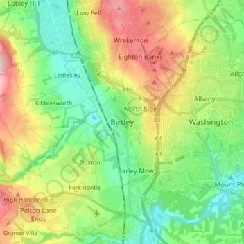
Name: Birtley topographic map, elevation, terrain.
Average elevation: 223 ft
Minimum elevation: -16 ft
Maximum elevation: 607 ft
Other topographic maps
Click on a map to view its topography, its elevation and its terrain.
District métropolitain de Gateshead
Royaume-Uni > Angleterre > Tyne and Wear
District métropolitain de Gateshead, Tyne and Wear, North East, Angleterre, Royaume-Uni
Average elevation: 266 ft