
Saint-Dizier-Leyrenne topographic map
Interactive map
Click on the map to display elevation.
About this map
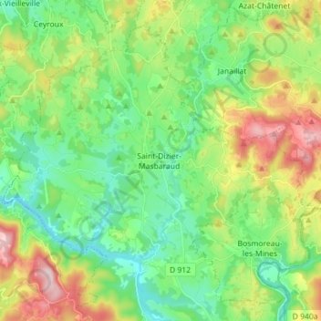
Name: Saint-Dizier-Leyrenne topographic map, elevation, terrain.
Average elevation: 1,506 ft
Minimum elevation: 1,214 ft
Maximum elevation: 2,100 ft
Other topographic maps
Click on a map to view its topography, its elevation and its terrain.
Pradeix
France > Nouvelle-Aquitaine > Creuse > Saint-Dizier-Masbaraud
Pradeix, Saint-Dizier-Leyrenne, Saint-Dizier-Masbaraud, Guéret, Creuse, Nouvelle-Aquitaine, France métropolitaine, 23400, France
Average elevation: 1,417 ft