
Ewigschneehorn topographic map
Interactive map
Click on the map to display elevation.
About this map
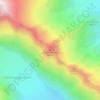
Name: Ewigschneehorn topographic map, elevation, terrain.
Average elevation: 9,403 ft
Minimum elevation: 8,068 ft
Maximum elevation: 11,542 ft
Other topographic maps
Click on a map to view its topography, its elevation and its terrain.
Hienderstock
Hienderstock, Guttannen, Verwaltungskreis Interlaken-Oberhasli, Verwaltungsregion Oberland, Berna, 3864, Svizzera
Average elevation: 9,229 ft
Oberaarhorn
Oberaarhorn, Guttannen, Goms, Verwaltungsregion Oberland, Berna, 3864, Svizzera
Average elevation: 10,184 ft
Lauteraarhorn
Lauteraarhorn, Guttannen, Verwaltungskreis Interlaken-Oberhasli, Verwaltungsregion Oberland, Berna, 3864, Svizzera
Average elevation: 10,869 ft
Mährenhorn
Mährenhorn, Guttannen, Verwaltungskreis Interlaken-Oberhasli, Verwaltungsregion Oberland, Berna, 3864, Svizzera
Average elevation: 7,667 ft
Bächlistock
Bächlistock, Guttannen, Verwaltungskreis Interlaken-Oberhasli, Verwaltungsregion Oberland, Berna, 3864, Svizzera
Average elevation: 9,091 ft