
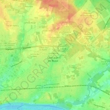
La Jarrie Mon Plaisir topographic map
Interactive map
Click on the map to display elevation.
About this map
Name: La Jarrie Mon Plaisir topographic map, elevation, terrain.
Average elevation: 367 ft
Minimum elevation: 292 ft
Maximum elevation: 430 ft
Other topographic maps
Click on a map to view its topography, its elevation and its terrain.
Le Grand Coquille
France > Centre-Val de Loire > Loiret > Saint-Jean-de-Braye
Le Grand Coquille, Saint-Jean-de-Braye, Orléans, Loiret, Centre-Val de Loire, France métropolitaine, 45800, France
Average elevation: 367 ft
Le Quiard
France > Centre-Val de Loire > Loiret > Saint-Jean-de-Braye
Le Quiard, Saint-Jean-de-Braye, Orléans, Loiret, Centre-Val de Loire, France métropolitaine, 45800, France
Average elevation: 367 ft
Le Petit Charbonnière
France > Centre-Val de Loire > Loiret > Saint-Jean-de-Braye
Le Petit Charbonnière, Saint-Jean-de-Braye, Orléans, Loiret, Centre-Val de Loire, France métropolitaine, 45800, France
Average elevation: 377 ft
L'Orbette
France > Centre-Val de Loire > Loiret > Saint-Jean-de-Braye
L'Orbette, Saint-Jean-de-Braye, Orléans, Loiret, Centre-Val de Loire, France métropolitaine, 45800, France
Average elevation: 348 ft
Maison Plate
France > Centre-Val de Loire > Loiret > Saint-Jean-de-Braye > Maison Plate
Maison Plate, Saint-Jean-de-Braye, Orléans, Loiret, Centre-Val de Loire, France métropolitaine, 45800, France
Average elevation: 367 ft
Charbonnière
France > Centre-Val de Loire > Loiret > Saint-Jean-de-Braye
Charbonnière, Saint-Jean-de-Braye, Orléans, Loiret, Centre-Val de Loire, France métropolitaine, 45800, France
Average elevation: 377 ft