
Miravete de la Sierra topographic map
Interactive map
Click on the map to display elevation.
About this map
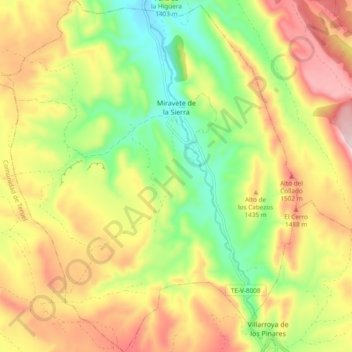
Name: Miravete de la Sierra topographic map, elevation, terrain.
Location: Miravete de la Sierra, Maestrazgo, Teruel, Aragon, Spain (40.52693 -0.75007 40.59890 -0.66166)
Average elevation: 4,511 ft
Minimum elevation: 3,904 ft
Maximum elevation: 5,187 ft
Other topographic maps
Click on a map to view its topography, its elevation and its terrain.
Bordón
Spain > Aragon > Maestrazgo
Bordón, Maestrazgo, Teruel, Aragon, Spain
Average elevation: 2,986 ft