
Col de la Pra topographic map
Interactive map
Click on the map to display elevation.
About this map
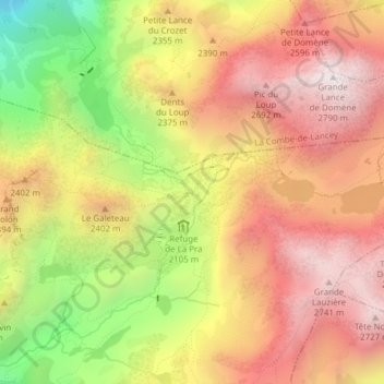
Name: Col de la Pra topographic map, elevation, terrain.
Average elevation: 7,454 ft
Minimum elevation: 5,184 ft
Maximum elevation: 9,094 ft
Other topographic maps
Click on a map to view its topography, its elevation and its terrain.
Les Eaux
France > Auvergne-Rhône-Alpes > Revel > Les Eaux
Les Eaux, Revel, Grenoble, Isère, Auvergne-Rhône-Alpes, France métropolitaine, 38420, France
Average elevation: 2,589 ft
Pré Raymond
France > Auvergne-Rhône-Alpes > Revel
Pré Raymond, Revel, Grenoble, Isère, Auvergne-Rhône-Alpes, France métropolitaine, 38420, France
Average elevation: 4,186 ft
Col de la Petite Vaudaine
France > Auvergne-Rhône-Alpes > Revel
Col de la Petite Vaudaine, GR549, Revel, Grenoble, Isère, Auvergne-Rhône-Alpes, France métropolitaine, 38420, France
Average elevation: 6,804 ft
Lac Merlat
France > Auvergne-Rhône-Alpes > Revel
Lac Merlat, GR549, Revel, Grenoble, Isère, Auvergne-Rhône-Alpes, France métropolitaine, 38420, France
Average elevation: 6,772 ft
Lac du Crozet
France > Auvergne-Rhône-Alpes > Revel
Lac du Crozet, GR549, Revel, Grenoble, Isère, Auvergne-Rhône-Alpes, France métropolitaine, 38420, France
Average elevation: 6,660 ft