
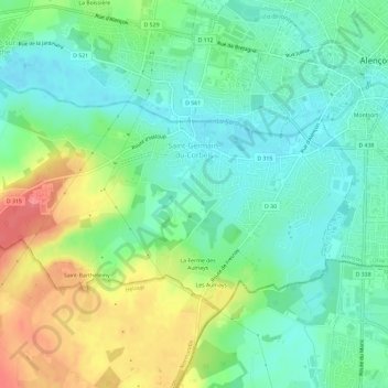
Saint-Germain-du-Corbéis topographic map
Interactive map
Click on the map to display elevation.
About this map
Name: Saint-Germain-du-Corbéis topographic map, elevation, terrain.
Average elevation: 499 ft
Minimum elevation: 413 ft
Maximum elevation: 663 ft
Other topographic maps
Click on a map to view its topography, its elevation and its terrain.
Montreuil-au-Houlme
Montreuil-au-Houlme, Argentan, Orne, Normandie, France métropolitaine, 61210, France
Average elevation: 732 ft