
Rüthi (SG) topographic map
Interactive map
Click on the map to display elevation.
About this map
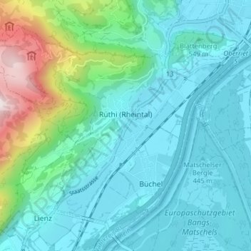
Name: Rüthi (SG) topographic map, elevation, terrain.
Location: Rüthi (SG), Wahlkreis Rheintal, St. Gallen, Switzerland (47.27661 9.50149 47.31048 9.56558)
Average elevation: 1,949 ft
Minimum elevation: 1,345 ft
Maximum elevation: 4,633 ft
Other topographic maps
Click on a map to view its topography, its elevation and its terrain.
Oberriet
Switzerland > St. Gallen > Wahlkreis Rheintal
Oberriet, Wahlkreis Rheintal, St. Gallen, Switzerland
Average elevation: 1,732 ft
Berneck
Switzerland > St. Gallen > Wahlkreis Rheintal
Berneck, Wahlkreis Rheintal, St. Gallen, 9442, Switzerland
Average elevation: 1,841 ft
Altstätten
Switzerland > St. Gallen > Wahlkreis Rheintal > Altstätten
Altstätten, Wahlkreis Rheintal, St. Gallen, Switzerland
Average elevation: 2,228 ft
Marbach
Switzerland > St. Gallen > Wahlkreis Rheintal > Marbach
Marbach, Wahlkreis Rheintal, St. Gallen, 9437, Switzerland
Average elevation: 1,470 ft