
Holzhäuseln topographic map
Interactive map
Click on the map to display elevation.
About this map
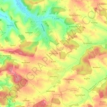
Name: Holzhäuseln topographic map, elevation, terrain.
Average elevation: 1,594 ft
Minimum elevation: 1,414 ft
Maximum elevation: 1,716 ft
Other topographic maps
Click on a map to view its topography, its elevation and its terrain.
Freidling
Deutschland > Bayern > Landkreis Landshut > Buch am Erlbach
Freidling, Buch am Erlbach, Landkreis Landshut, Bayern, 84172, Deutschland
Average elevation: 1,594 ft
Holzen
Deutschland > Bayern > Landkreis Landshut > Buch am Erlbach
Holzen, Buch am Erlbach, Landkreis Landshut, Bayern, 84434, Deutschland
Average elevation: 1,601 ft